


Mechelen
in collaboration with Peter Jochems
in collaboration with Peter Jochems
The present study draws inspiration from the excellent online article "Markt 54–56 (afgebroken),"1by George Buzing en Gerrit Verhoeven, which traces the history of Mechelen, the house where the painter Vermeer grew up and may have painted for a few years. As far as the author of the present article is aware of, one of the pre-1885 photographs and three prints picturing Mechelen considered herein appear for the first time in Buzing's and Verhoeven's article, and not in any mainstream Vermeer-related publication.
On April 23 1641, Vermeer's father, Reynier Jansz. Vos, bought a large and heavily mortgaged inn on the Grote Markt (old Dutch, "Groote Marct"; know today as De Grote Markt or, in English, Great Market Square or Market Square ) called Mechelen. He paid 200 guilders in cash and assumed two mortgages for the total value of 2,500 guilders. Mechelen had four fireplaces, which tells us of its size, one of the largest construction of the Groote Markt. It was the corner with the Oude Manhuissteeg (Old Mens' Alley), a narrow alleyway that lead to Voldersgracht via a small bridge (Oudemanhuisbrug). The fact that Mechelen was also a tavern where people could stay overnight explains why it was larger than the normal inns. Its strategic position, with the town hall on one side and the Nieuwe Kerk on the other side, made it an ideal meeting place for Delft's citizens. Archives reveal that local Delft artists also used to meet for shop-talk and likely, conduct business, which was very usual at the time. The first mention of Mechelen, presumably named after the Flemish town of the same name, dates to 1540.1
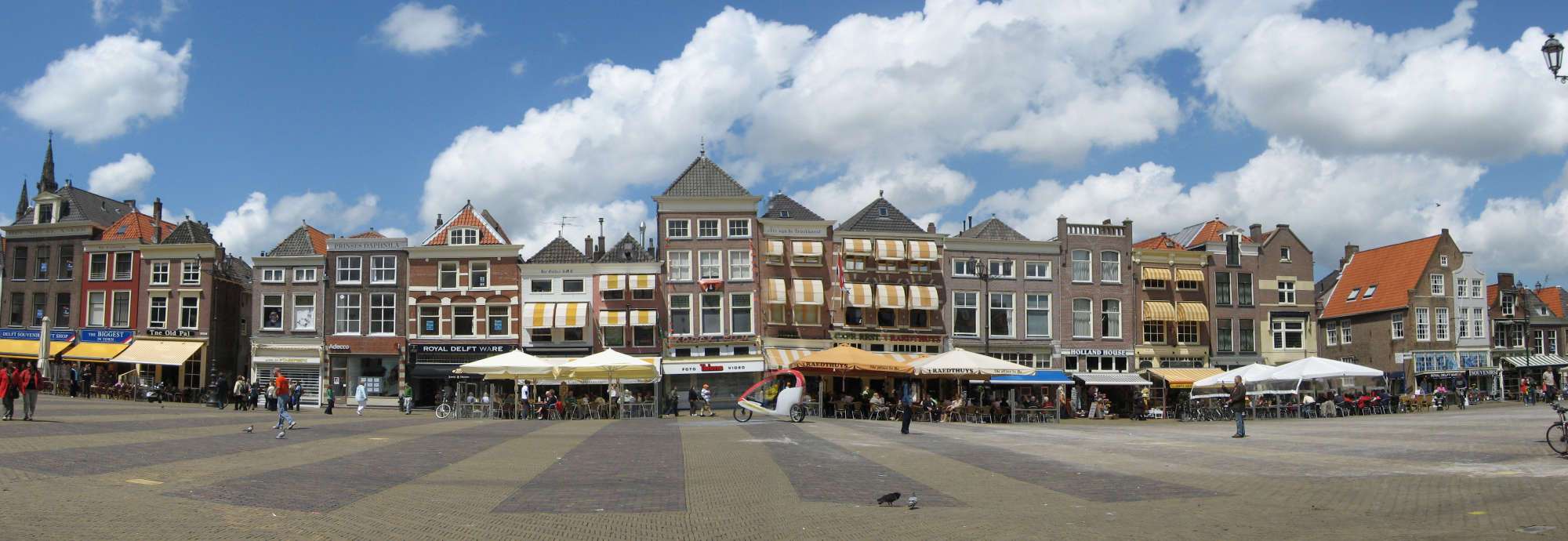 fig. 1 The north side of the Groote Markt, Delft, today
 Like all the neighboring houses on the north side of the Groote Markt, the backside plunged straight down into the Voldersgracht canal. The narrow Oude Manhuissteeg ran alongside Mechelen to a bridge over the canal behind. Unfortunately, Mechelen was demolished in 1885 to improve access to and from the Groote Markt, and no building stands in its place (fig. 2 & 3).
 fig. 2 The Oude Manhuissteeg today with the reconstructed Guild of St. Luke in the background
 fig. 2 The Oude Manhuissteeg today with the memorial statue of Hugo Grotius (philosophic attorney and writer who advanced the notion of international law in the early 17th century)
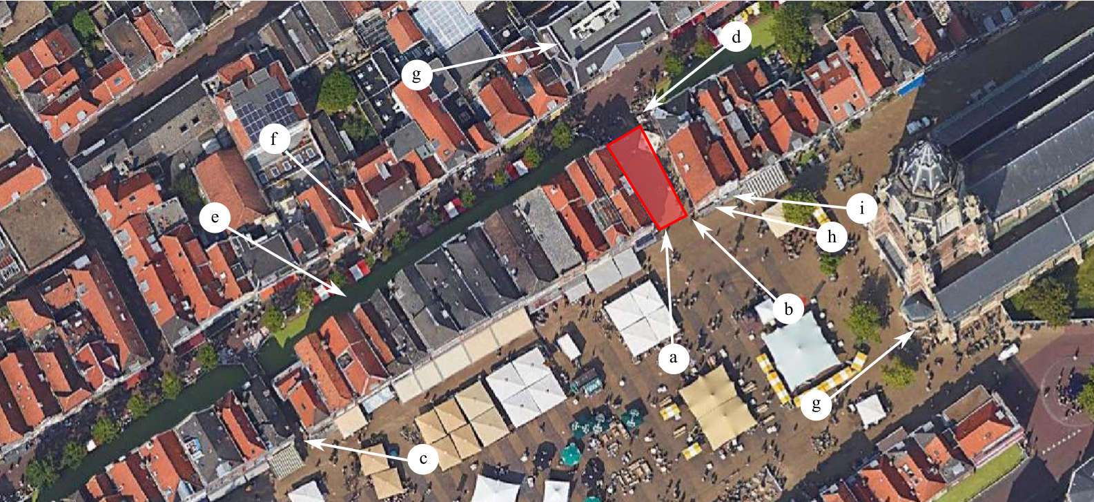 fig. 3 GROOTE MARKT, DELFT & IMMEDIATE ENVIRONS in GOOGLE EARTH VIEW
  fig. 4 GROOTE MARKT, DELFT & IMMEDIATE ENVIRONS from KADASTRALE MINUUT (1832)
Click here to download a high-resolution scan of the Funeral of Prince Maurits in 16252 by Gillis van Scheyndel (I).
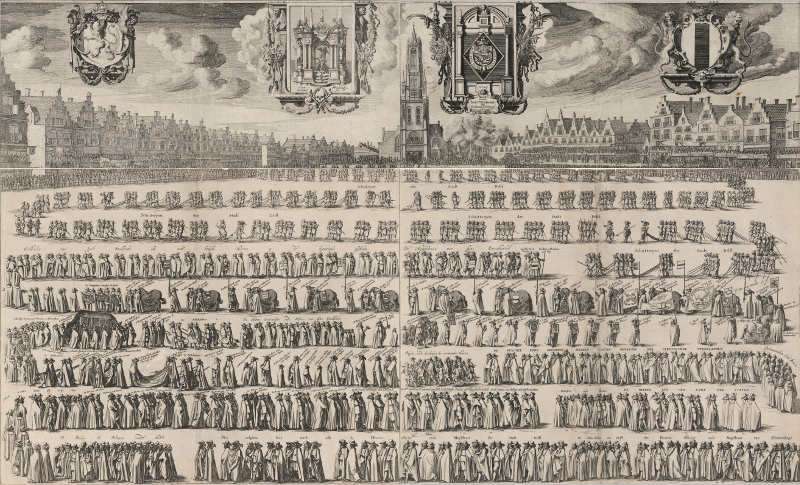
Although the first mention of what would eventually be known as Mechelen dates back to 1540, the first reliable visual representation appears on the top left-hand sheet (fig. 5) of a four-sheet engraving illustrating the funeral of Prince Maurits in 1625, published between 1625 and 1626 by the Haarlem etcher and draftsman Gillis van Scheyndel (c. 1595– c. 1660). This sheet pictures a long row of the typically narrow buildings located on the north side of Delft's Groote Markt.
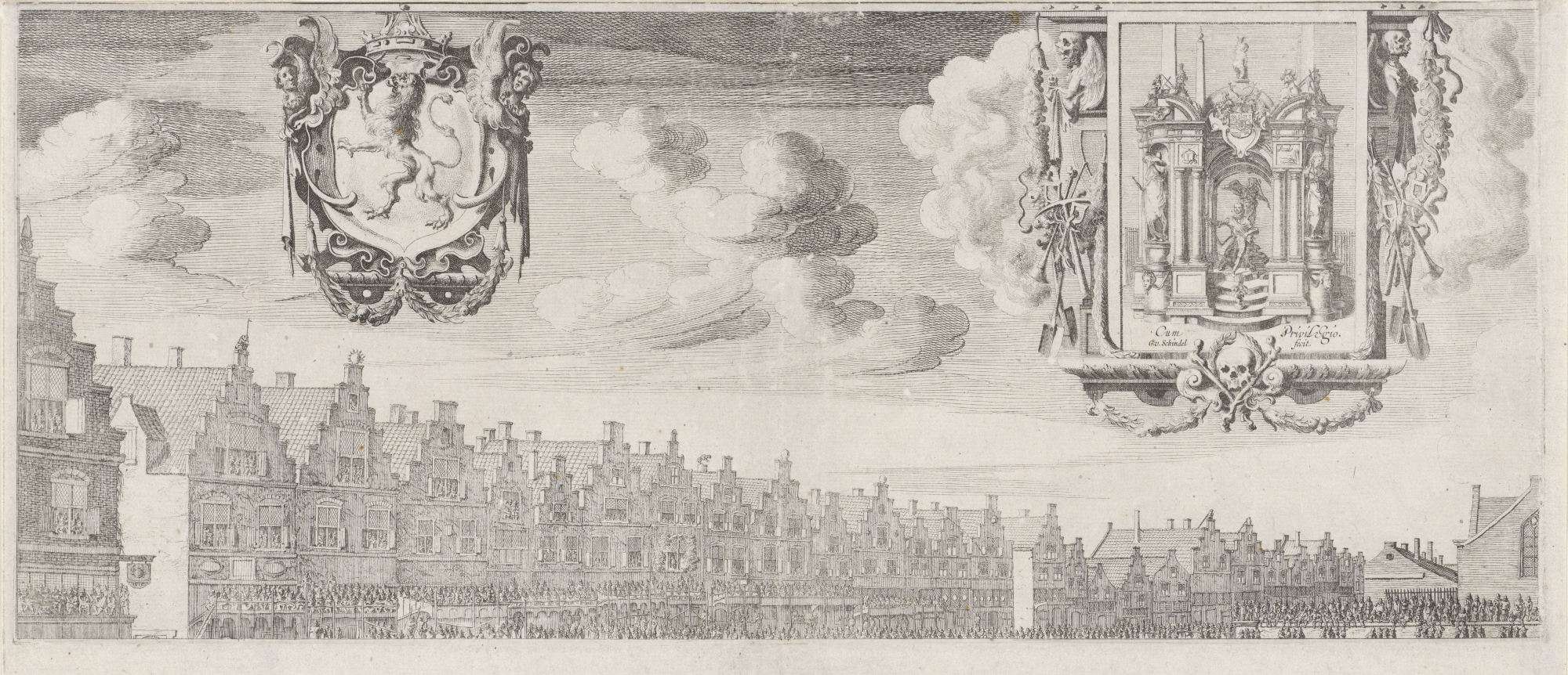 fig. 5 Funeral of Prince Maurits in 1625 (top left of four sheets)
 fig. 6 Funeral of Prince Maurits in 1625 (detail; top left of four sheets)
While it is true that in 1620 a birds-eye-view map of Delft appears in Joris Hoefnagel's Civitates Orbis Terrarum (fig. 7), it is doubtful that it provides reliable information about how Mechelen might have appeared in those years. While both the Oude Manhuissteeg and the Oude-Manhuys (Old Mens' House), whose range was converted in 1661 to create the Guild of St Luke, are clearly identifiable, the Oude Manhuissteeg is much wider than in all later representations, and the orientations of gabled roofs of the north side buildings of the Groote Markt run from east to west rather than north to south (fig. 8). Unless the buildings between the Oude Manhuissteeg and the Bonte Ossteeg were torn down and rebuilt between 1558 (the date of the first edition of Civitates Orbis Terrarum) and 1625 (when Van Scheyndel's engraving of the Groote Markt was published) we must assume, unsurprisingly, that individual houses were not drawn with topographical accuracy in mind. The primary aim of atlases like Hoefnagel's was not to produce well-balanced landscapes, but to give as much information as possible in a pleasing visual form, in reality a kind of super guide book.3
 fig. 7 Map of Delft from: Civitates Orbis Terrarum. Liber tertius
 fig. 8 Map of Delft from: Civitates Orbis Terrarum. Liber tertius (detail)
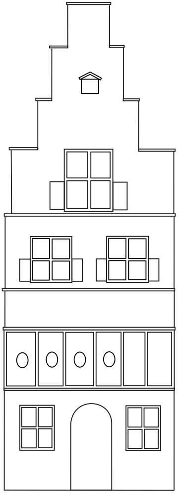 fig. 9 Diagram of the facade of Mechelen as seen in the print of Gillis van Scheyndel
 In any case, like in many subsequent representations of the area Van Scheyndel's Mechelen can be instantly identified because it is located on the east corner of Groote Markt and the Oude Manhuissteeg. In most perspectival views the alleyway is signaled by a rectangular patch of empty wall that belongs to the side of the building on the opposite (east) corner of the Oude Manhuissteeg, today, Markt 62.
The buildings facing the Groote Markt in Van Scheyndel's print vary in proportion, and, with only two exceptions, feature stepped gables. The widths and heights of the facades as well as the types and disposition of the windows vary enough as to suggest they may be based to some degree on actual observation. This supposition is comforted by two facts. First, the number of buildings—14—between the two alleys that connect the Groote Markt to Voldersgracht (Oude Manhuissteeg and Bonte Ossteeg) is nearly the same as those that survive today—13—but without counting the demolished Mechelen. Second, the relative proportions and some of the architectonic features of the three houses opposite Mechelen on the Oude Manhuissteeg appear to mime those that are standing today. While the first two buildings of the print were at some point in time brought under a single roof, which gives rise to the curious merging of the facades we see today (fig. XX), the disposition of the windows and their relative heights suggest that Van Scheyndel's rendition is not a flight of artistic fantasy. Furthermore, the building to the right of the two just mentioned is more squat than its two companions to the left and, as today, it does not have a stepped gable but two gently sloping curves. Thus, the individualized treatment of the facades as well as corresponding number of buildings would suggest that the building that appears in the location of Mechelen may be a reasonable accurate portrayal.
 fig. 10 Funeral of Prince Maurits in 1625 (detail) and Markt 62 and Markt 64
In Van Scheyndel's rendering, Mechelen has two floors, a loft, a stepped gable and a winch at the top of the facade used for lifting heavy or bulky items to the top floors. The ground floor shows a central, arched doorway flanked by two windows each with four lites. Directly above is a row of six latticed windows. On the second floor there are two large windows each with four lites and open shutters on the bottom lites. The loft has an even larger window with four lites and, again, open shutters on the bottom lites. Given the rather uncertain perspective of the drawing it is difficult to judge the building's size relative to the adjacent building,s but it seems to be somewhat wider than the first two buildings to the left. The Oude Manhuissteeg appears somewhat wider that one would expect.
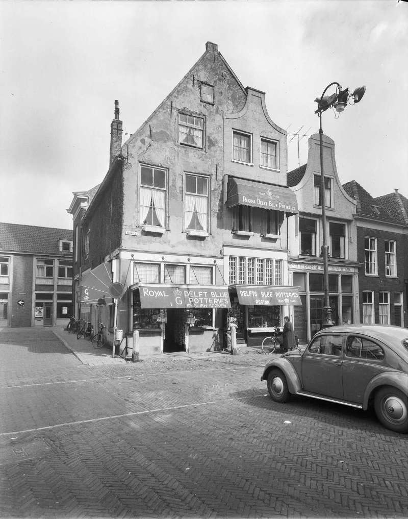 fig. 11 Corner of today's Markt 62 and Markt 64
 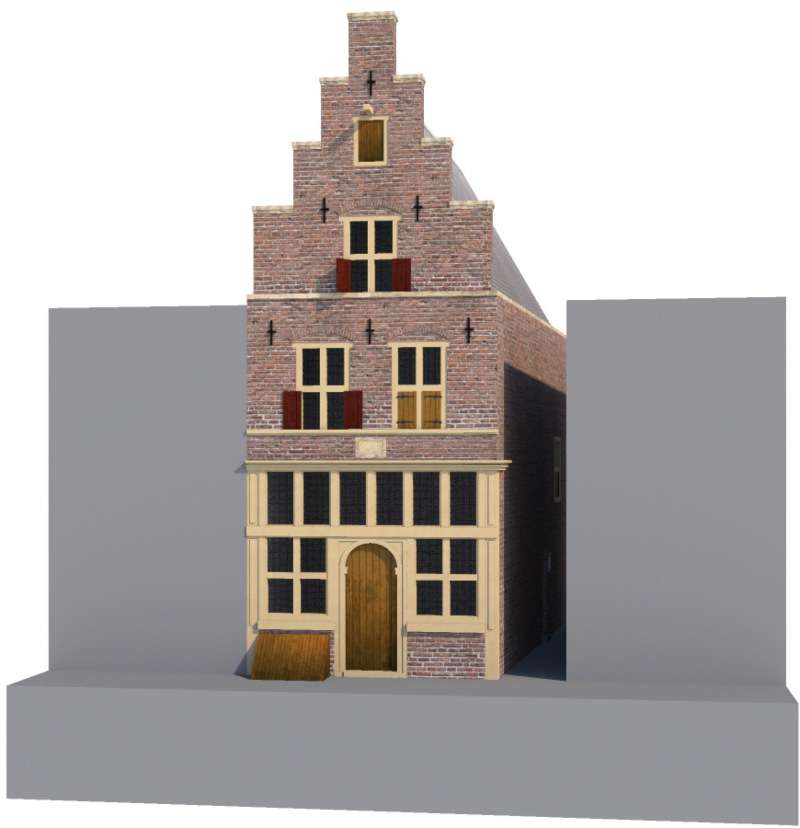 fig. 12
Hypothetical reconstruction of the building corresponding to Mechelen in Gillis van Scheyndel's print
fig. 12
Hypothetical reconstruction of the building corresponding to Mechelen in Gillis van Scheyndel's printClick here to download a high-resolution scan of the Funeral of Prince Maurits in 1625 by an anonymous engraver, after Gillis van Scheyndel (I)
In circa 1649–1651, another commemorative engraving of funeral of Prince Maurits in 1625 (fig. 13) was published by an anonymous printmaker, after Van Scheyndel. Although it follows the architectonic scheme of the Van Scheyndel print, it is far less detailed (fig. 14) and contributes nothing our knowledge of Mechelen.
 fig. 13 Funeral of Prince Maurits in 1625
 fig. 14 Funeral of Prince Maurits in 1625(detail)
 Click here to download a 16,000 x 12,000 (100 MB) scan of the Kaart Figuratief.
In 1675, the former mayor of Delft, Dirck Evertsz. van Bleyswijck (1639–1681), author of the foundational book on Delft, Beschryving der Stadt Delft (Description of the City of Delft), was commissioned by the municipality to produce a map of Delft with accompanying images of buildings and cityscapes, which is known as the Kaart Figuratief (fig. 15). When the map was ready in 1678, the epic ensemble consisted of a birds-eye view of Delft from the west, Delfshaven seen from the Maas, 22 images of buildings, two maps of Overschie and Delfshaven, four family coats of arms of Delft mayors and a short text with a description of the city of Delft.
While the most important buildings in Delft are represented with adequate fidelity, the individual features of the hundreds of domestic dwellings may be standardized to one degree or another. Moreover, art historical researchers claim that there are generally fewer houses than there were in reality. Unfortunately, although the Oude Manhuissteeg and the Bonte Ossteeg are clearly indicated, it is difficult to count the number of houses between them. Nonetheless, the birds-eye-view allows the spectator to clearly view the position of Mechelen with respect to its immediate environs (fig. 16), including the Groote Markt, the Oude Manhuissteeg, Voldersgracht and the Guild of St Luke. From what can be made out, Mechelen is shown with a gabled roof and two (?) chimneys.
 fig. 15 Kaart Figuratief
 fig. 16 Kaart Figuratief (detail)
 Click here to download a high-resolution scan of Leonard Schenk's View of the Delft Market Square
 fig. 17 A View of the Delft Market Square
 fig. 18 A View of the Delft Market Square (detail)
 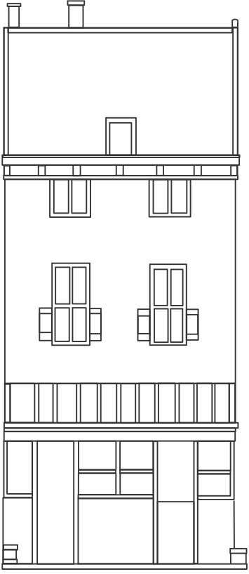 fig. 19 Diagram of the Mechelen in Leonard Schenk's View of the Delft Market Square
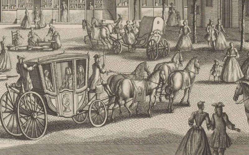
In circa 1730, the printmaker Leonard Schenk (1696–1767), a Dutch engraver editor and book seller, published an engraving of the north side of the Groote Markt (fig. 17) after a drawing made by Abraham Rademaker (1677–1735), in which Mechelen is portrayed frontally (fig. 18). However, the facade is considerably different from the previous Van Scheyndel rendering in both proportion and architectural features. Instead of one door of the ground floor, the Schenk print represents two lateral ones. The latticed windows of the ground floor directly above are much lower. Above the latticed windows are two windows with four lites and a pair of open shutters on the lower lites. Above these are two other windows which may belong to the loft. The roof is no longer the gable type that slopes to the sides. Instead, the plane of the roof rises from the deticulated cornice on the building's front side and then descends somewhere behind, vaguely recalling the structure of the so-called salt-box roof. At first glance the rising and descending planes of the roof do not appear extensive enough to span the entire depth of Mechelen, but its back slope may have joined a gable type roof, out of sight in the print (fig. 21). Such hybrid roofs can be occasionally detected in Van Bleyswijck's birds-eye-view (fig. 20). Whatever the case, the Schenk building appears many times in Vermeer-related literature.
But how true to life is Schenk's print, and what can we deduce from the rendering of the house that stands in the place of Mechelen?
Obviously, it is theoretically possible that during the one hundred years that separate the Schenk and Van Scheyndel renditions, the actual buildings of the Markt were remodeled. And certainly, the individual facades of the Schenk version are so carefully articulated they might induce the casual observer to accept them as observed fact. To convince us of his perspective illusion and delight the eye of the beholder, the skillful draftsman meticulously catalogued minute incidences of architecture and urban life : crawling vegetation, decorative garlands, metal anchor rods, exterior shelves stocked with merchandise. Buildings are fitted with a variety of differently configured windows, upper story dormers, pulleys and series of exterior shelves stocked with merchandise on the ground floor.
However, there are, by any standard, glaring inconsistencies with reality. First, there are only 9 buildings between the Oude Manhuissteeg and the Bonte Ossteeg when we know that there were at the very least 13. Second, the first three buildings to the right of the Oude Manhuissteeg bear little or no resemblance to those we observe in both Van Scheyndel's rendition or to those of the corresponding buildings that have survived (fig. 10 & 11), which, in fact, are surprisingly in agreement considering the almost 400 years that separate the two renditions. Third, the perspective is utterly impossible: neither the Nieuwe Kerk nor the Stadhuis could have been brought within the incredibly compressed field of view of the print. It is obvious that the scope of the illustration was primarily to provide a view of Delft's prosperous citizens engaged in pleasant pastimes in the midst of the picturesque setting of the Groote Markt, in a sort of urban paradise as it were.
 fig. 20 A detail of a house showing a roof in a Kaart Figuratief possibly similar in construction to that of Mechelen in Leonard Schenk's View of the Delft Market Square
 fig. 21 Diagram of the roof of Mechelen in Leonard Schenk's View of the Delft Market Square as seen from the back side
 Click here to download a high-resolution scan of Georg Balthasar Probst's View of the Nieuwe Kerk, Delft
Georg Balthasar Probst (1732–1801) was a German engraver and publisher from Augsburg. Many other members of his family were also printers and publishers at the same Augsburg firm. He was known especially for his vue d'optique ("optic view") of city views, which were meant to be seen through an optical box fitted with a convex lens in order to enhance the sense of three-dimensionality. Common features of the vue d'optique are dramatic perspectival views and bright colors. "According to the Getty Research Institute, street performers would set up viewing boxes—variously known as zograscopes, optiques, optical machines or peepshows—with a series of prints giving a pictorial tour of famous landmarks, dramatic events and foreign lands. Vues d’optique were also purchased by Grand Tour travelers as souvenirs to be viewed at home as a parlor activity."4 When viewed through the apparatus, the text title, which was printed in reverse, would appear in its correct orientation. The view of the Groote Markt is, in fact, an example of a Probst's vue d'optique, proven by the reversed title on the top of the print.
The facade of the building corresponding to Mechelen exhibits two, or perhaps, three floors each with three windows and, curiously, no entranceways on the ground level (fig. 23). However, the roof seems to be similar to that of Schenk's print. Moreover, however crude in drawing and perspective, there are 13 buildings between the Oude Manhuissteeg and the Bonte Ossteeg, which is likely not a coincidence. Such accuracy is most likely owing to the fact that Probst based his prints on previously made prints. Evidently, he neglected to record the features of the individual buildings seeing that topographical accuracy was not the primary point of such prints (fig. 22).
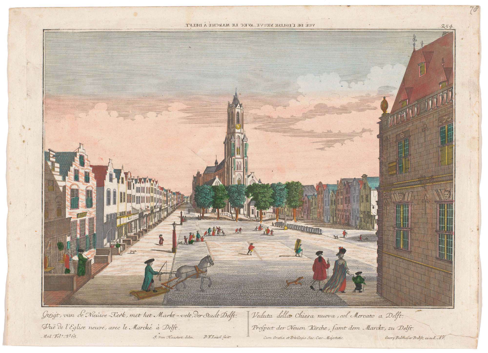 fig. 22 View of the Nieuwe Kerk, Delft
 fig. 23 View of the Nieuwe Kerk, Delft (detail)
 Click here to download a high-resolution scan of Simon Fokke's The Funeral Procession of Willem IV in Delft, 1752.
In 1752, Simon Fokke, a Dutch designer, etcher and engraver, published an etching of the funeral procession of Willem IV in Delft, 1752. Fokke made quick time of the endeavor lifting the background Leonard Schenk's view of the Groote Markt (fig. 24). The architectural features of the buildings are shoddily drawn. They add little to print on which it is based except smoke lazily issuing from a few chimneys and figures that look out from the many windows to the historic procession below. It would seem that a sort of temporary gallery had been erected just above the ground floor stretching along the entire length of the facades (fig. 25) in order to allow some of the massive public to witness the scene from a better vantage point.
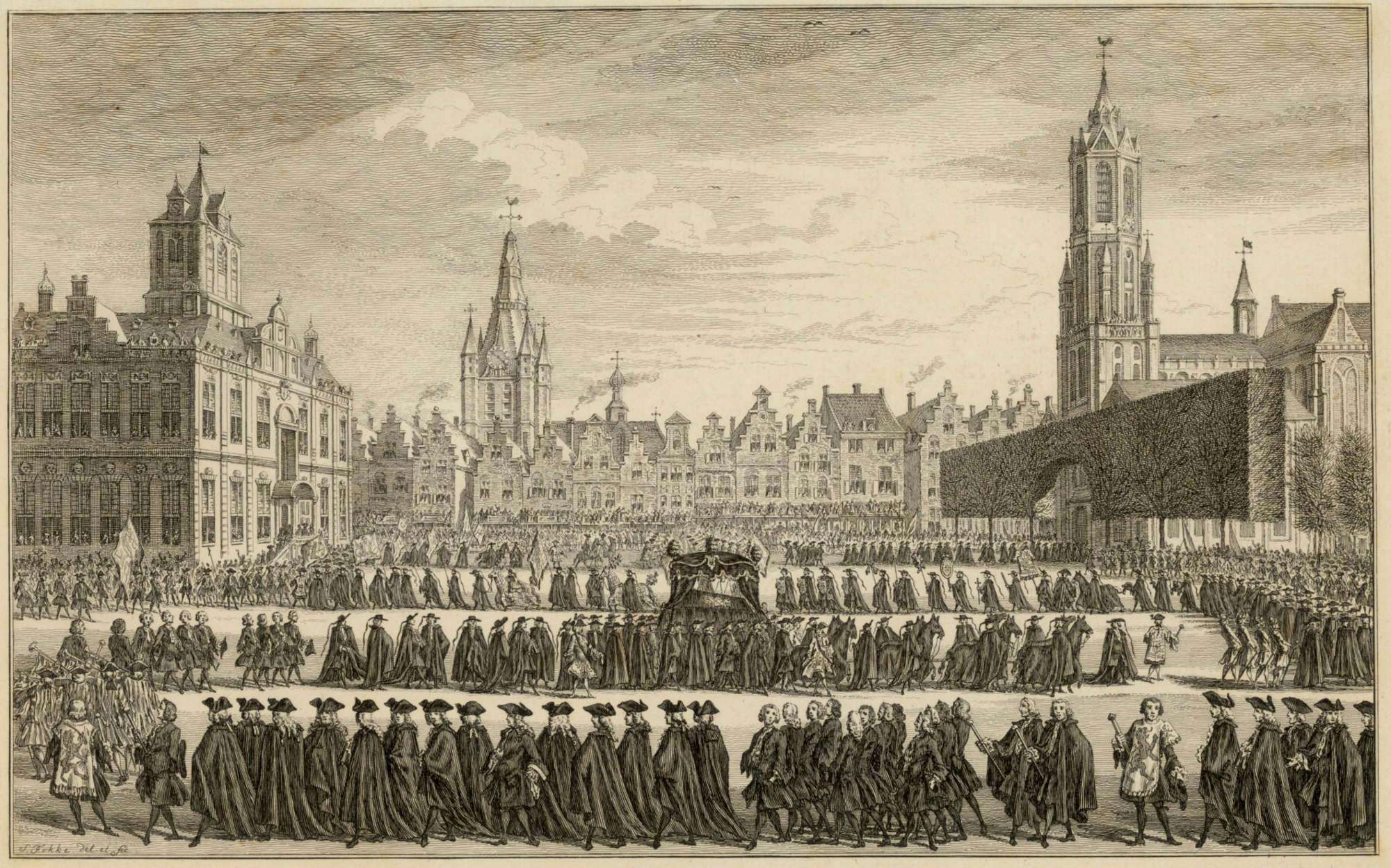 fig. 24
The Funeral Procession of Willem IV in Delft, 1752
fig. 24
The Funeral Procession of Willem IV in Delft, 1752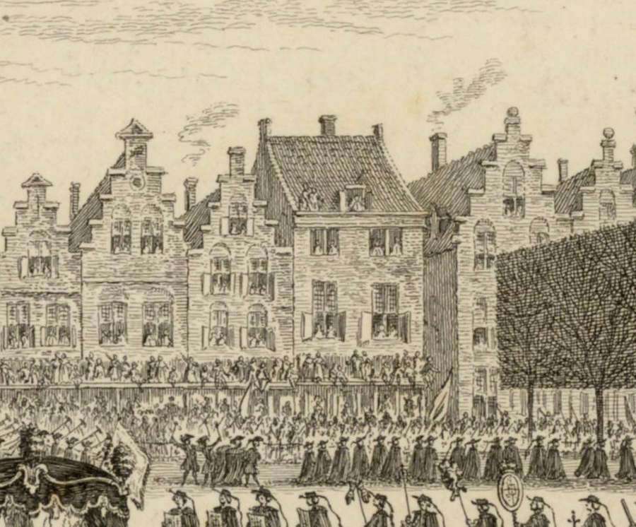 fig. 25
The Funeral Procession of Willem IV in Delft, 1752 (detail)
fig. 25
The Funeral Procession of Willem IV in Delft, 1752 (detail)Click here to download a high-resolution scan of Johannes Jelgerhuis' View of the Nieuwe Kerk, Delft
In circa 1757–1759, the printmaker Johannes Jelgerhuis (1770–1836), a Dutch painter and actor, published an engraving of the Groote Markt (fig. 26) which illustrates a jubilant holiday called ‘Feest bij het planten van de vrijheidsboom, 1795 (The Planting of the Tree of Freedom in Delft). The left side of the print shows the row of houses on the north side of the Groote Markt in strongly accelerated perspective. In the very foreground what is most likely the Bonte Ossteeg can be clearly made out (fig. 27). The first facades are carefully rendered showing the same sort of protruding ledges visible in the Probst print, from which citizens enjoy the spectacle.
Although there is only there is no evidence of the Oude Manhuissteeg, one of the facades is comparable in various features to the Mechelen that appears in the earlier View of the Nieuwe Kerk, Delft, by Georg Balthasar Probst. Both have the three floors, the top two of which have three windows. Moreover, neither renditions shows a step-gabled roof, and both are fitted with an awning that projects from the ground floor. However, in the Jelgerhuis view there are only nine or ten buildings between the Oude Manhuissteeg and the Bonte Ossteeg, while the in the Probst veiw there are thirteen. While both versions exhibit elements that effectively coincide with known architecture of the north side of the Groote Markt, it is evident that neither artist was particularity concerned with topographical accuracy, and so, both may be considered artful weaves of fact and fiction.
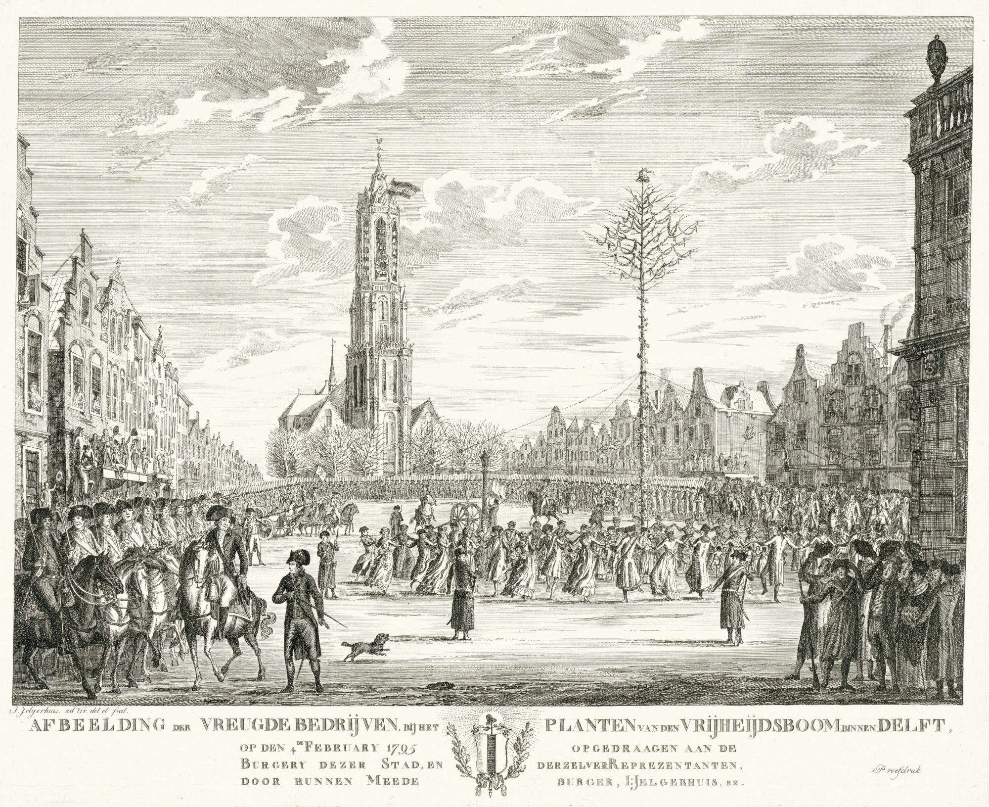 fig. 26 Feest bij planten van vrijheidsboom te Delft, 1795 Afbeelding der vreugdebedrijven, bij het planten van den vrijheidsboom binnen Delft (The Planting of the Tree of Freedom in Delft)
  fig. 27 detail of: Feest bij planten van vrijheidsboom te Delft, 1795 Afbeelding der vreugdebedrijven, bij het planten van den vrijheidsboom binnen Delf (The Planting of the Tree of Freedom in Delft) )
Click here for high-resolution image of the Kadastrale Minuut
Between 1811 and 1832, the municipality of Delft drew up a detailed cadastral plan of Delft, referred to as the Kadastrale Minuut (fig. 28), which was used for the purpose of taxation. The historic map allows us to examine with confidence the exact geography of the town as it was in 1832. It has been often referenced in Vermeer literature because, as Kees Kaldenbach claims, the city plan had probably changed little from the seventeenth century. By 1832 measurements had beome much more precise and the old towns were not yet affected by the arrival of the railway or the motorcar.
The seventeenth-century maps of Delft by Johan Blaeu and the Kaart Figuratief, as well as their derivatives, have been widely used in Vermeer literature up to this point. These maps have the drawback of depicting a lower number of buildings on any given block than there actually were.
The historic map known as the Kadastrale Minuut map of Delft depicts the precise geography of the town as it was in 1832. Up until that period, mapmaking had been a craft. However, from the Napoleonic era onwards maps were produced by scientific methods. This map was used as a tool in registering the ownership of lots and real estate. For this reason the Kadastrale Minuut map is more accurate than the Kaart Figuratief birds-eye view maps. The one area which radically changed in the seventeenth century was the northeastern corner, devastated by the tremendous gunpowder explosion of October 12, 1654. But little changed in the layout of Delft between about 1650 and 1832 and so this map is quite suitable.
*by Kees Kaldenbach
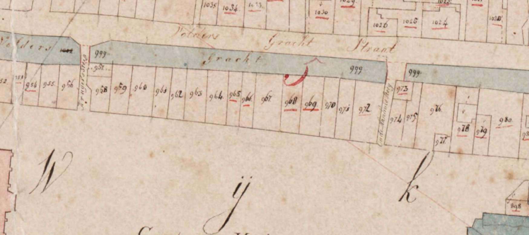 fig. 28 Cadastral map 1811-1832 (showing the Groote Markt): minute plan Delft, South Holland, section C, sheet 01
  fig. 29 The Oude Manhuissteeg today (courtesy Peter Jochems)
 In 1828, Gerrit Lamberts (1776–1850) made a sketch of the Oude Manhuissteeg facing the Guild of St. Luke (fig. 30). Lamberts was a Dutch artist and curator of the Rijksmuseum when it was located in the Trippenhuis. Born in Amsterdam, he was also a watercolorist, draughtsman and engraver, known for his landscapes, architectural views and watercolors of art galleries.
The right-hand side of Lambert's drawing shows the east side of today's Markt 62, on the left-hand side, the west side of Mechelen. However, the true subject of the drawing must have been the facade of the Guild of St Luke (the guild of artists and artisans) which, being a painter, may have stimulated Lamberts' curiosity. Along the Mechelen wall two steps lead to a small doorway with a wrought iron hand guide, and in the distance there is a small window with four lites, one of whose two lower shutters is open. On the opposite wall a side window can be seen about half way down the alley. Nearer to the observer, Lambert has drawn a smallish, unadorned opening at the foot of the wall that allowed air and a little light to enter into the building's basement. Curiously, this modest opening is still present today (fig. 29).
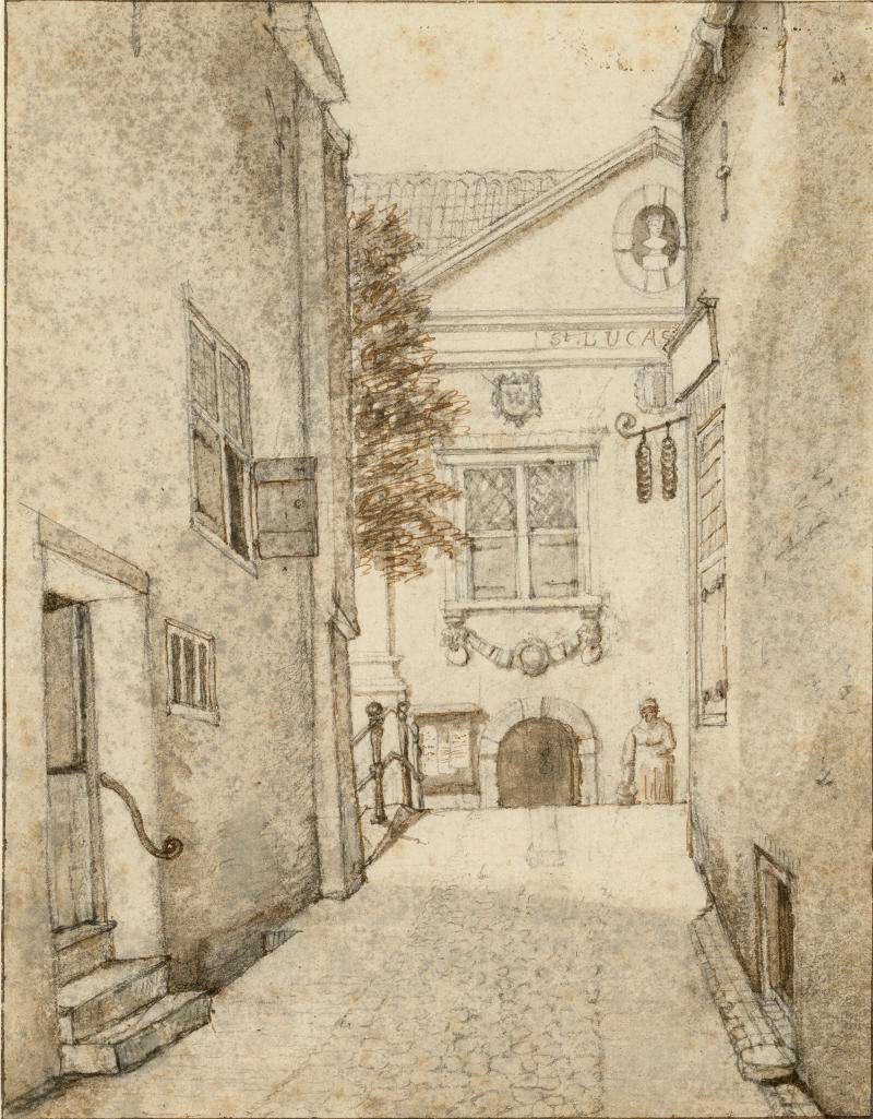 fig. 30 Oude Manhuissteeg
Click here to download a high-resolution scan of Antony Last's Groote Markt of Delft, on 4 April 1849
 fig. 31 Diagram of Mechelen drawn from print by Carel Last
 In 1849, Carel Christiaan Antony Last (1808–1876 ), a Dutch printmaker, published a somber lithograph (fig. 32) of the north-west corner of the Groote Markt on April 4, 1849, picturing the funeral procession of King William II. To the right of the imposing Nieuwe Kerk entranceway are represented 7 facades, and to the immediate left, the Oude Manhuissteeg and then Mechelen. To the right of the Oude Manhuissteeg stand two facades of today's Markt 62 and Markt 64 (fig. 12), which appear to strangely merge into a single facade, although they are covered by a single gabled roof. This curious double facade, as well as the squat building to the immediate right, are reminiscent to the those that stand today (fig. 11 & 12). This testifies to the fact that the lithograph was based to some degree on direct observation.
Mechelen is different from previous representations (fig. 33). The facade isunsually squat, and the ground floor has an expansive central doorway and two lateral windows. The upper floor, with two large windows, is crowned by a cornice and a hip roof.
 fig. 32 The Groote Markt of Delft, on 4 April 1849
 fig. 33 The Groote Markt te Delft, on 4 April 1849 (detail)
Click here to download a high-resolution digital image of The Tower of the Nieuwe Kerk, Delft by Christiaan Bos.
Roughly a decade after Last published his Groote Markt of Delft, on 4 April 1849, Christiaan Bos published a delicately colored lithograph (fig. 34) which depicts the Groote Markt dominated by the soaring Nieuwe Kerk in the center. To the left of the church and a group of trees appears the same double facade of we see today, also present in the same guise in all the pre-1885 photographs (fig. 35). A dark gap signals the narrow Oude Manhuissteeg. Directly to the left of the gap stands Mechelen, which at first glance appears similar to the Last print. The roof, as well, is the same hip type, with a central dormer window. The ground floor presents, from left to right, a window, a door, a window and another door while the upper floor presents three windows, different from Last's print.
What to make of these discrepancies?
First, the Mechelen of the Bos print is, although not highly resolved in detail, very similar to the Mechelen which appears in pre-1885 photographs most probably made after Bos' lightograph. Thus, either Mechelen was remodeled in the span of about 10 years which separates the two prints, or alternatively, the Last version is less accurate. If we take into account that the merged Markt 62 and Markt 64 facades are represented with demonstrable accuracy, it is not easy to understand why Last would have dedicated less attention to the uncomplicated facade of Mechelen. In any case, the accuracy of Mechelen in the Bos print is confirmed by all the pre-1885 photographs in which Mechelen can be made out clearly.
 fig. 34 The Tower of the Nieuwe Kerk, Delft
  fig. 35 The Tower of the Nieuwe Kerk, Delft (detail)
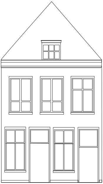 fig. 36 Diagram of Mechelen form pre-1885 photographs
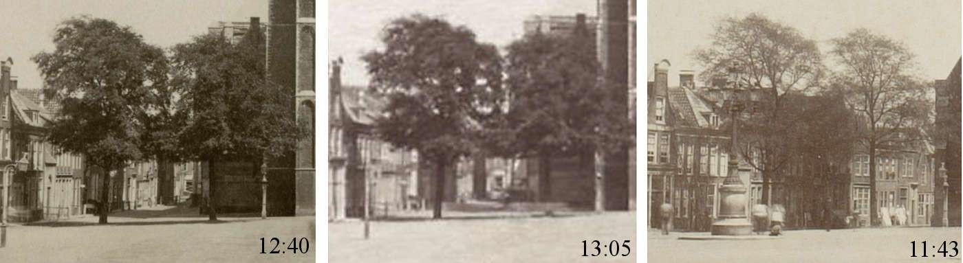
 Luckily, at least three photographs of Delft's Groote Markt were taken before Mechelen5 was destroyed in 1885 (fig. 41, 42 & 45), revealing the building's simple facade. Photographs taken after 1885 can be recognized not only because Mechelen is no longer visible, but for the fact that in 1886 a bronze statue of Hugo Grotius by Franciscus Leonardus Stracké was erected in front of the Nieuwe Kerk (fig. 53).
Even though Mechelen itself was not the point of interest of any pre-1885 photographer, these rarely published photographs reveal what Mechelen was like before its demise. One might imagine that the basic structure of the building, its perimeter walls and floors would have been those least likely to be altered over time, while the external finish and the disposition and types of windows and doorways must have been remodelled quite frequently.
The first photograph (fig. 41) was taken from beneath the facades of the south side of the Groote Markt at approximately 11:43, while the successive (fig. 43) approximately from the middle at 12:40, and the last (fig. 44) from a few steps to the right at 13:05. We know that Jacobus Hendricus Johan (Henri) de Louw (1851–1944), a Dutch photographer based in Delft and The Hague, took the first photograph while the photographers of the other two remain anonymous.
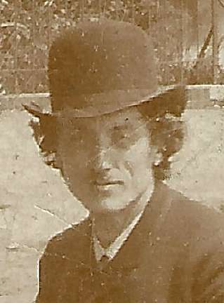 fig. 37 Henri de Louw
 Despite their evident similarities, these photographs were likely taken in different days if not different seasons. The foliage of the four trees that flank the Nieuwe Kerk in the 12:40 and 13:05 photographs is notably more dense that of the 11:43 photograph. On the other hand, the 12:40 and 13:05 photographs bear closer resemblance to one another. For example, the patterns created by the patches of background sky that peep through the foliage of the left-hand trees are unusually similar. And on close inspection what appears to be a broom leaning against the facade of the left-hand perimeter of the building to the immediate left of Mechelen in the 12:40 photograph seems to be present in the 13:05 photograph as well. Moreover, the perspectives tell us that the two were taken from close to the same spot on the immense Groote Markt. Thus, it is not out of the question that they were taken on the same day and by the same photographer, perhaps even De Louw, who, after all, was based in Delft.
The 11:43 image shows a capped man (with a hand-held satchel and a cane?) standing in line with the left-hand flank of the Nieuwe Kerk and a second, slightly blurred male figure who partially obscures the lower part of Mechelen's facade. The 12:40 photograph features a standing male figure similar to the previous one, this time directly under the entrance to the Nieuwe Kerk, and a second very blurred male figure to left left, closer to the viewer. The 13:05 image shows the Groote Markt completely empty.
Given the front-facing static posture and the length of exposure time of period photographic equipment, it seems very likely that the focused figures were instructed to stand still for the time required to expose them correctly. Early cameras had a very slow shutter speed, meaning that the shutter remained open exposing the plate to light for a longer period of time. Any movement caused bluriness. Although early daguerreotype images required an exposure of around twenty minutes, by the early 1840s it had been reduced to about twenty seconds. Even so, photography subjects needed to remain completely still for long periods of time for the image to come out crisp and not blurred by their movement.
Despite its blurred figure, the 11:43 photograph provides the widest view of Mechelen's facade (fig. 41), since it was taken from a less acute angle than the successive two, closer to the south side of the Groote Markt. We can clearly see that the building has two floors and a loft, as in the Last (fig. 32) and Bos (fig. 34) prints.
The 12:40 photograph allows us to make out the facade's features with the greatest clarity (fig. 43). The ground floor features a series of four tightly fit openings, in succession from left to right: a window, a door, a second window and a second door. The upper partitions of the windows seem to be fitted with shutters, while the lower partitions are fitted with two elongated lites, just like those of the ground-floor windows of the second building to the right of Mechelen. The structure of the doors are more difficult to make out although both are topped with a window with a roughly square frame.
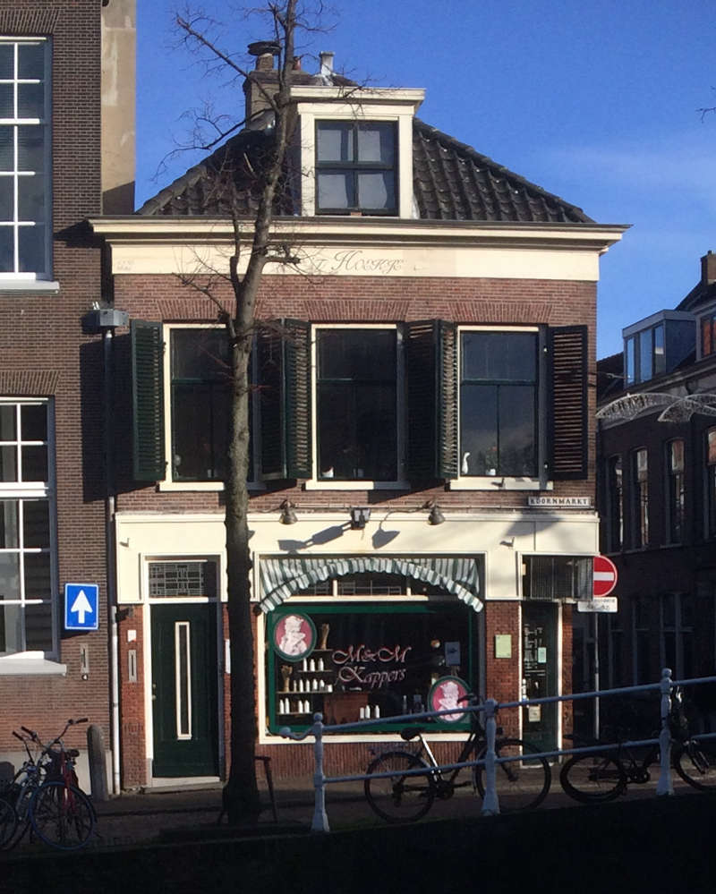 fig. 38
A building on the corner of Breestrat and Koornmarket in Delft that may evoke the sense of the dimensions of Mechelen as it appears in the Last and Bos prints, and the pre-1885 photographs.
fig. 38
A building on the corner of Breestrat and Koornmarket in Delft that may evoke the sense of the dimensions of Mechelen as it appears in the Last and Bos prints, and the pre-1885 photographs.
The first two windows of the upper story are fitted with shutters, divided in two sections by rails. In the 12:40 and 13:05 photographs the lower partitions of the shutters are open while in the earlier 11:43 image they are closed. The third window is composed to six lites, the upper two apparently fixed.
Similar to both the Last and Bos print, a hip roof encloses a loft that is fitted with a central windowed dormer that projects vertically beyond the plane of the pitched roof. Such dormers were used to increase usable space of the loft and provide light to attic-level bedrooms. Although in the top of Mechelen's roof seems to rise slightly higher than that of the building to the right, perspective orthogonals show that it is slight lower.
Differently from the pre-1885 photographs, the Last print shows a central door flanked by two large windows on the ground floor while only two windows appear on the upper floor. Instead, despite the fact that the Bos print is far less defined than the photographs, it is in agreement with the number and positions of the facade's openings.
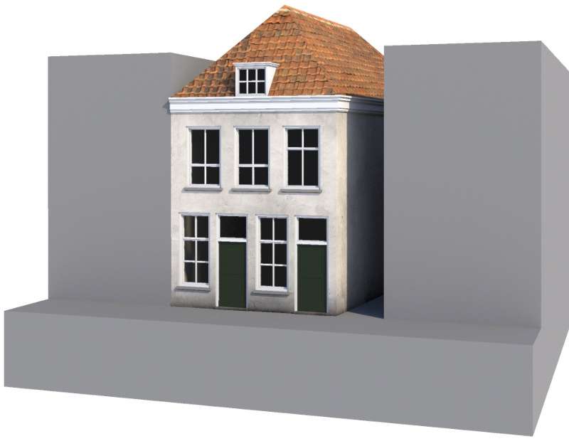 fig. 39 Hypothetical reconstruction of the building corresponding to Mechelen in pre-1885 photographs
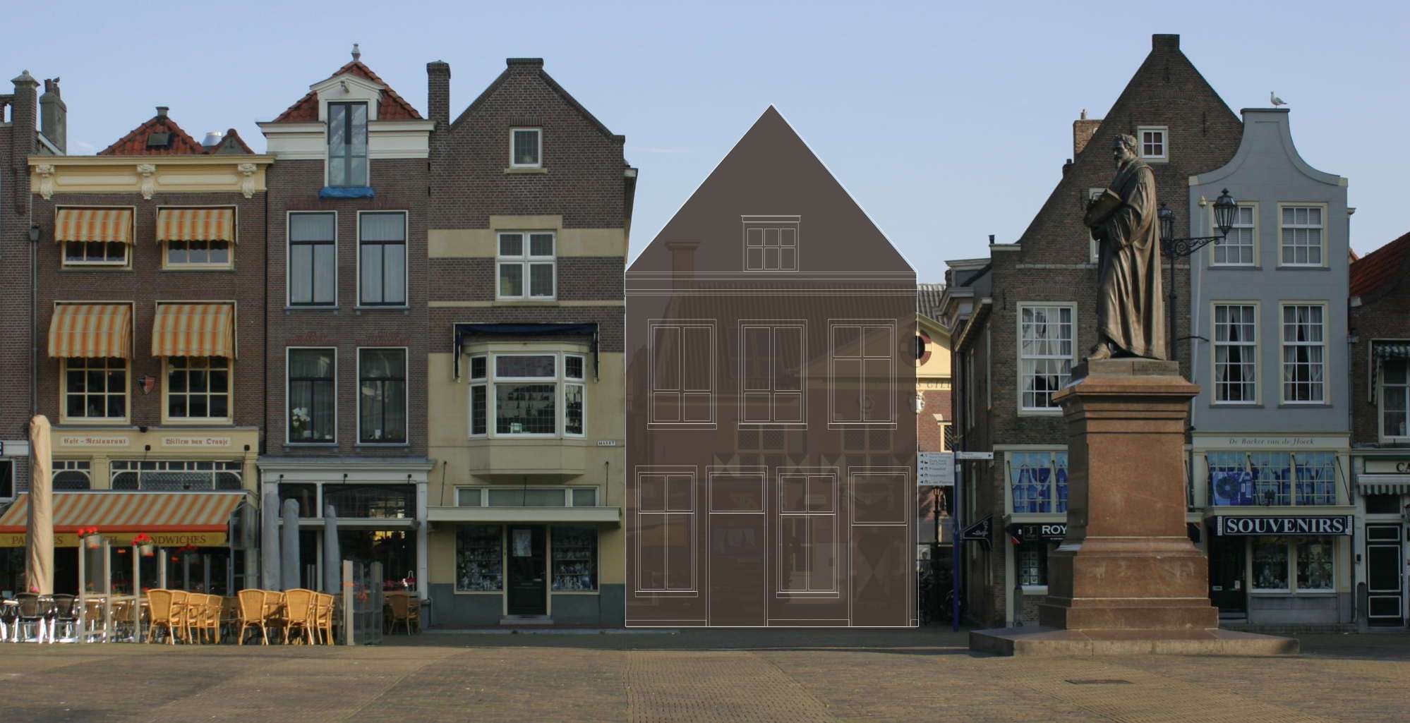 fig. 40 Diagram of Mechelen as seen in pre-1885 photographs inserted into today's Delft
 Click here for a high-resolution downloadable image.
 fig. 41
Groote Markt, Delft
fig. 41
Groote Markt, Delft fig. 42
Groote Markt, Delft
fig. 42
Groote Markt, Delft fig. 43
Groote Markt, Delft
fig. 43
Groote Markt, Delft fig. 44
Groote Markt, Delft
fig. 44
Groote Markt, Delft fig. 45
Groote Markt, Delft
fig. 45
Groote Markt, Delft fig. 46
Groote Markt, Delft
fig. 46
Groote Markt, Delft fig. 47 Pre-1885 panoramic photograph of Delft
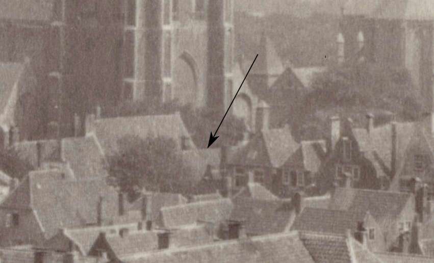 fig. 48 Detail of a pre-1885 panoramic photograph of Delft, with arrow indicating the roof of Mechelen
 fig. 49 The Cameretten seen from the Warmoesbrug in the direction of the Voldersgracht
 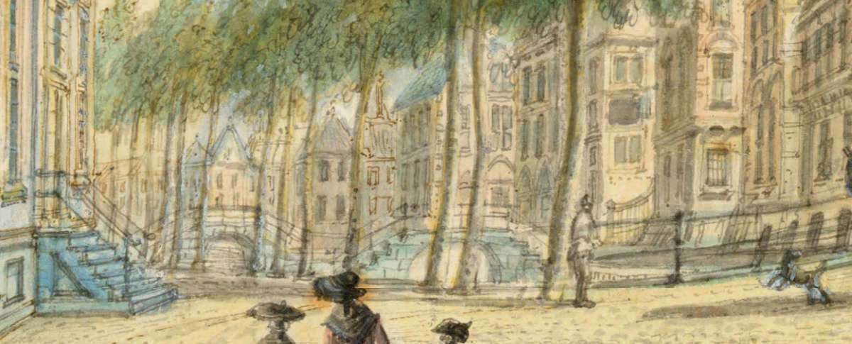 fig. 50 The Cameretten seen from the Warmoesbrug in the direction of the Voldersgracht (detail)
An mid-eighteenth-century watercolor (fig. 49) by the Dutch painter Jacob Elias la Fargue (1735–1778) shows a somewhat fanciful look down Voldersgracht from Cameretten, a small square in the center of the city of Delft. The buildings below the tower of the Nieuwe Kerk are bound by the Voldersgracht canal on the back side and by the Groote Markt, which is not visible, on the front side. In the distance appear two arched bridges (fig. 49), presumably those which still allow the Oude Manhuissteeg and the Bonte Ossteeg to cross over the canal from the Groote Markt to the Voldersgracht.
The left-hand bridge is the bridge that spans the Oude Manhuissteeg, which Vermeer must have crossed over many times. Although fanciful in execution, La Fargue's painting nonetheless furnishes an idea what the Oudemanhuisbrug looked like before it was lowered in 1885, following the blueprint made the architect by CJ de Bruijn Kops. (fig. 54 & 55).
 fig. 51 Voldersgracht a seen from the same point of view of the Jacob Elias la Fargue watercolor
 fig. 52 detail of Voldersgracht a seen from the same point of view of the Jacob Elias la Fargue watercolor with:
 Click here to download a high-resolution digital image of the blueprint proposed in 1885 for the widening of the Oude Manhuissteeg alley with a new bridge over the Voldersgracht.
 fig. 53 Measurements of Mechelen drawn from Kadastrale Minuut scaled to extant location
 "In May 1885, city architect CJ de Bruijn Kops made a plan (fig. 48 & 49) for a wider and lower bridge over the Voldersgracht to facilitate traffic to and from the Groote Markt. Previously, "an advertisement in the Delftsche Courant of 10 June 1885, the municipality called on candidates for the demolition of the Mechelen house and the construction of the new bridge."6 At the request of the municipal council, De Bruijn Kops attempted first to acquire the house east of the Oude Manhuissteeg so that it could be demolished to make way for the wider venue. However, he came to believe that the building was not so dilapidated after all and more importantly, the three owners would have had to be bought out before it could be pulled down."7 Thus, it was decided that Mechelen be demolished.
The Kops plans allow us to determine the exact position and dimensions of Mechelen with respect to the surrounding constructions. According to the blue print (fig. 54), Mechelen was 6.75 meters (c. 22 feet) wide on the Markt-side and 8 meters (c. 26 feet) at the Voldersgracht. The Oude Manhuissteeg was, instead, 1.80 meters (c. 6 feet) on the Markt-side and 2.20 meters (c. 7 feet) at the Voldersgracht.
If one scales these dimensions to the current site, the combined lengths of Mechelen and the Oude Manhuissteeg fit precisely in the space left by the demolished Mechelen (fig. 53).
 fig. 54 Widening of the Oudenanhuis alley with a new bridge over the Voldersgracht
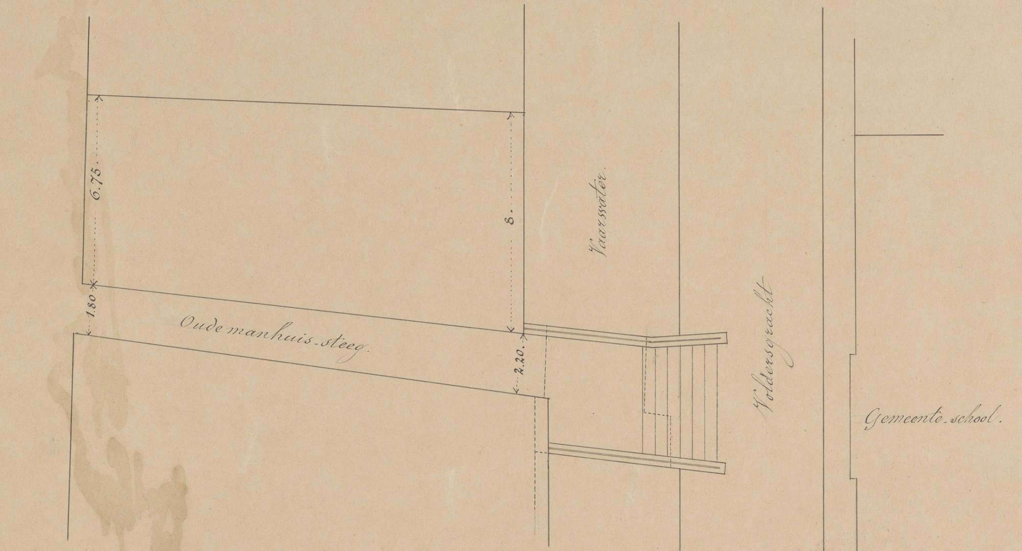 fig. 55 Widening of the Oudenanhuis alley with a new bridge over the Voldersgracht (detail of Mechelen and the Oude Manhuissteeg)
 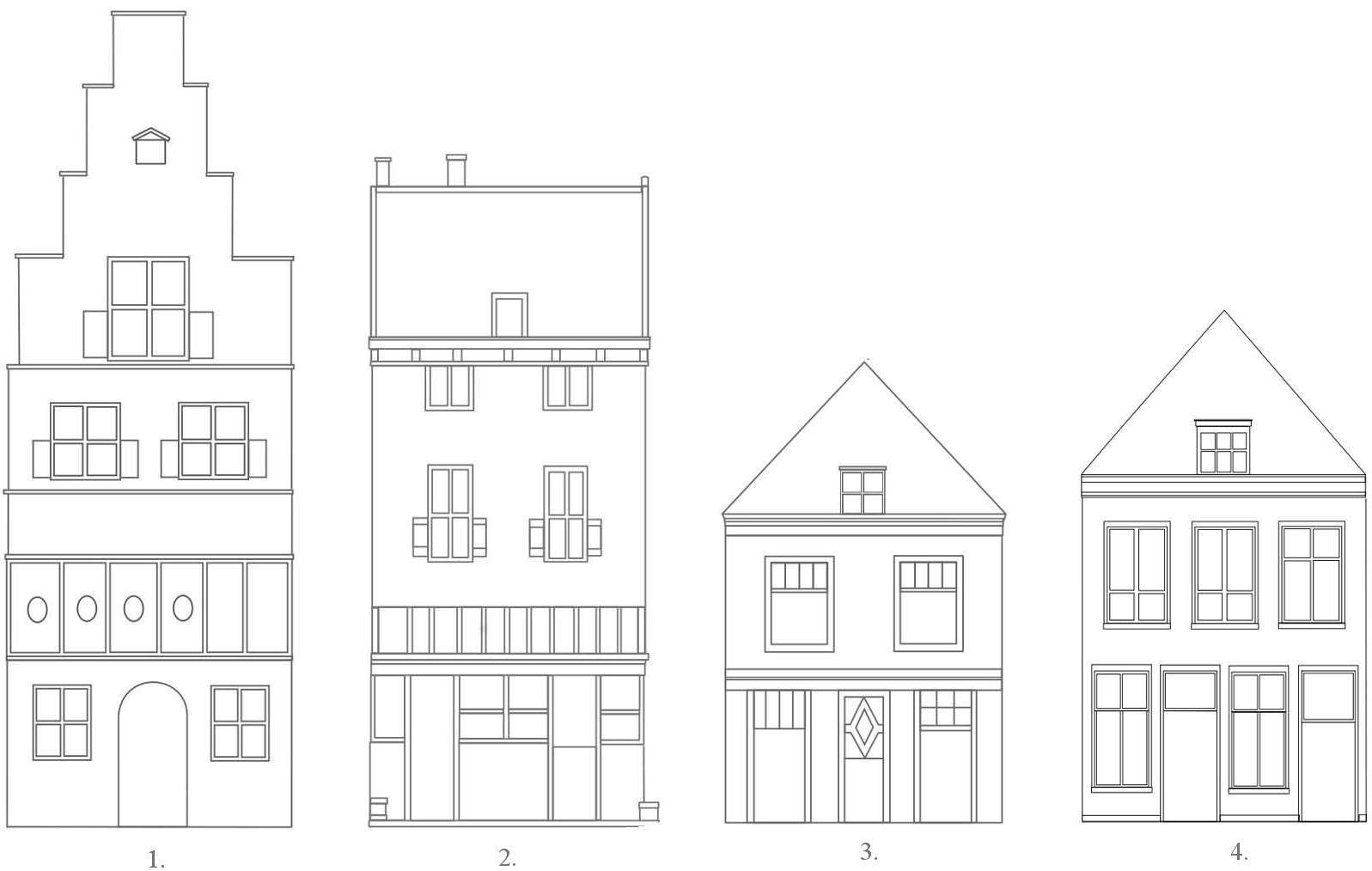 fig. 56 Diagrams of Mechelen facades (diagrams have been resized to have equal widths)
 fig. 57
the Groote Markt, Delft
fig. 57
the Groote Markt, Delft fig. 58
the Groote Markt, Delft
fig. 58
the Groote Markt, Delft If you discover a  or anything else that isn't working as it should be, I'd love to hear it! Please write me at: jonathanjanson@essentialvermeer.com