The following is a list of maps of Delft, of which the most notable are: Delft after the fire of 1536 (fig. 11), a detailed plan of the city of Delft from Joan Blaeu's town book of the Netherlands published in 1649 (fig. 12) and the Kaart Figuratief (fig. 13).
A map of Delft after the Great Fire of 1536 (fig. 1).
This map was unusually painted on canvas and represents Delft after the Great Fire, probably caused by lightning, in 1536. Since it is not executed on panel, but on canvas, it is unlikely that it had been made in the time soon after the Great Fire. More likely, it is a copy of the original, which is now lost. Nothing is known about the maker or the reasons for its creation. The sections of the city destroyed by the fire are painted in lighter colors than those which had remained intact. The inscription on the surrounding dark border reads: "Viertien Kercken veel menschen ende huusen, al sonder ghetal syn in Delft ghebrant dat Raethuys ende die vleis hal 1536" (Fourteen churches, numerous people and countless houses are burnt in Delft the Town Hall and the Meat Hall 1536).
"After the fire of 1536, which consumed much of the western half of Delft, more than two thousand houses had to be rebuilt. They changed little in plan, but their street facades orgevels—in Holland, the term 'gables' refers to structures that rise from the ground—were constructed almost exclusively of stone, in a mixture of Late Gothic and Renaissance styles. New neighborhoods, the new town hall, and other civic buildings of the early to mid-seventeenth century (such as the foursquare Vleeshal, or Meat Hall, of 1650) further contributed to Delft's distinctive character. Much of the city's attraction for the visitors must have come from the fact that the squares and canals were bordered by buildings that dated mostly from about 1550 to 1650. In addition, the two great churches had been restored and parts of the convents had been reconstructed as public institutions or workshops."Walter Liedtke, ed., Vermeer and the Delft School (New York: Metropolitan Museum of Art, 2001), 28.
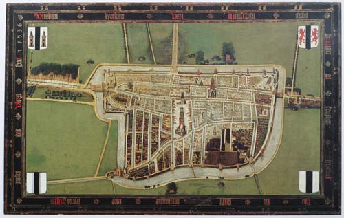 Fig. 1 Delft After the Great Fire of 1536 (West-South-West above)
(anonymous)
Oil on canvas, 92 x 160 cm.; with strip around the map: 116 x 183 cm.
Gemeente Musea Delft
Collection Stedelojk Museum Het
A map of Delft by Jacob van Deventer (fig. 2), c. 1557.
This map of Delft is one of a series of over 250 maps of cities and towns in the Spanish Netherlands, commissioned by King Philip II. Since the maps were used to assist the siege of the rebel cities in the Low Countries, they had to be reliable. The Dutchman Van Deventer (c. 1500/1505–1575), the most skilled mapmaker of his time, visited the cities personally to measure them systematically, as well as the rivers, canals and other natural landmarks surrounding each city, as can be seen in his map of Delft. The gates and fortifications, the tallest structures in the towns and the surrounding buildings around the cities were drawn precisely so that the Spanish invaders could plan their battles and eventually find their way around inside the cities with ease. Van Deventer sent a drawing of each city to King Philip II.
Van Deventer made all his maps according to the same scheme, using a scale of c. 1:8,000. Most were made in three versions: the first was a "minute" version or first draft of the city in its nearer surroundings, based on topographical data that was collected by on-site surveying, with texts in Dutch. Van Deventer worked on this monumental project until his death in 1575. In the course of fifteen years, he created between approximately 250 and 260 city maps, covering an area from Friesland to what is now the north of France, and reaching into Luxembourg and the west of Germany.

Jacob van Deventer
c. 1557
A map of Delft (fig. 3 & 3a) in the Civitates Orbis Terrarum by Georg Braun (1541–1622) and Franz Hogenberg (1542–1600), first "state" (1581).
The Civitates Orbis Terrarum, also know asthe "Braun and Hogenberg," is a six-volume town atlas and the greatest book of town views and plans ever published: it contains 363 engravings, sometimes beautifully colored. It was one of the best-selling works in the last quarter of the 16th century. "Braun wrote the text accompanying the plans and views on the verso side of the engravings. A large number of the plates were engraved after the original drawings by the prolific Joris Hoefnagel, who was a professional artist and copper engraver. The text on the cartouche reads: "Delphum, a highly cultivated city in Holland, named after the canal of the same name, in Dutch Delft."
This great city atlas would eventually contain 546 prospects, bird's-eye views, and map views of cities from all over the world. Braun, a cleric of Cologne, was the principal editor of the work, and was greatly assisted in his project by the close and constant interest of Abraham Ortelius, whose Theatrum Orbis Terrarum of 1570 was, as a systematic and comprehensive collection of maps of uniform style, the first true atlas.
The volumes were originally published in Latin, followed by German and French translations.
: R.V. Tooley, preface to the reproduction edition of Civitates Orbis Terrarum, World Publishing, 1966
The Civitates Orbis Terrarum was the first atlas of world cities and one of the most important books published in the late 16th century. Although led by Braun and Hogenberg, the books were created by a large team of writers, engravers, and artists. R.V. Tooley writes: "The Civitates is one of the great books of the World…it was the first serious attempt to give graphic representations of the main cities of the World, with a wealth of factual detail. In the main, the buildings in each view are shown in elevation, and while the ordinary buildings are stylized, the principal buildings are reproduced from actual drawings on the spot, and these, and the main streets, can be recognized today. Further, the editors gave additional factual information as a deliberately planned policy, such as the heraldic arms of the city, and the nature of the surrounding countryside, whether wooded or arable, grazing land, vineyards, or gardens. The importance of waterways is stressed by the careful delineation of stone bridges, wooden pontoons, flat-bottomed ferries, moles, wharves, and jetties; the ports with ocean-going craft, the inland waters with river traffic. Varieties of land travel are depicted, pedestrians, horsemen, wagons, coaches, and palanquins. Small vignettes illustrate the trade, occupations and habits of the locality, agriculture, paper-making, and textiles. The law is represented by various forms of punishment, gibbets, wheels, floggings etc. A distinctive feature of the plates is the insertion of large figures in the foreground to illustrate local costume. Those figures are out of proportion necessarily. The general multiplication of detail slightly offends certain commentators who fail to appreciate the purpose of the editors. Their primary aim was not to produce well-balanced landscapes, but to give as much information as possible in a pleasing visual form, in reality a kind of super-guide book. This was done so magnificently that the result was an art as decorative as it was informative. The whole forms a wonderful compendium of life in Europe in the sixteenth century. And, as city growth in early times, with a few obvious exceptions, was more or less static, even further it gives a visual printed record of medieval Europe, and is one of the most valuable sources remaining to the student and historian of these periods."
Georg Braun & Joris Hoefnagel
Date of the first edition: 1558
Copper engraving, 35.5 x 48.5 cm.
A map of Delft in the Civitates Orbis Terrarum by Braun and Hogenberg, second "state" (1581) and in the Stedenatlas by Jan Janssonius (1657).
A map of Delft (fig. 4) in the publisher Christophe Plantin's (c. 1520––1589) edition of Ludovico Guicciardini's Beschrijving der Nederlanden (original title: Descrittione di tutti I Paesi Bassi (1581, 1582 and 1588).
Guicciardini's volume is one of the most detailed and best documented contemporary descriptions of the Low Countries. As such, its account has become an integrative part of the historical narrative on the history of the Low Countries. It distinguishes itself from other cosmographic sources of the Renaissance "through its comprehensive scope, analytical approach, and the rich and varied sources the author used.
Guicciardini (1521–1589) was an Italian writer and merchant from Florence who lived primarily in Antwerp from 1542 or earlier. His best-known work, the Descrittione di Lodovico Guicciardini patritio fiorentino di tutti i Paesi Bassi altrimenti detti Germania inferiore (1567; Description of the Low Countries), was an influential account of the history and the arts of the Low Countries, accompanied by city maps by various leading engravers.

Ludovico Guicciardini
Published in London by Peter Short for Thomas Chard
1593
A small map of Delft (fig. 5) in Francesco Valesio's Raccolta di le piu illustri et famose Città di tutto il Mondo (c. 1600).
Most plates unsigned. 111 plates are by Valesio and are signed variously: Fr. Vallegio, Frco. Valegio, Franco. Valezp. Five plates are by Martin Rota, three of which are dated to 1572.
Valesio (1670–1742) was an Italian diarist and archeologist, who lived in Rome near San Carlo al CorsoSan Carlo al Corso is a prominent basilica in Rome, Italy, dedicated to Saint Charles Borromeo, a cardinal and archbishop of Milan in the late 16th century. Situated on the bustling Via del Corso, this church is a notable example of Baroque architecture in Rome. It was designed by the architect Onorio Longhi and later completed by his son, Martino Longhi the Younger, in the 17th century. The basilica's façade, designed by Pietro da Cortona, is particularly striking, characterized by its grand columns and intricate details. where he kept a large library, which became a meeting point for scholars and antique dealers.

Francesco Valesio (sometimes spelled Valegio)
1595
Etching with hand-coloring
A map of Westland (fig. 6) shows the relationship between Delft and Rotterdam, by the surveyor Matthijs Jansz. de Been van Wena, in 1606.
Note the canals connecting the cities, which enabled the free flow of people and thus labor, capital, and ideas throughout the country. In 1539, the best-known professional surveyor of his time, Jacob van Deventer, was ordered to survey and draw a map of the territory of Delfland. Although six copies of this manuscript map were likely ordered, only a few have been preserved. It is presumed that this map was used as a wall map until 1606, when it was replaced by a wall map by Van Wena (who died in 1619; also known as Mathijs Jansz. van Delft) painted in oil on panel, which was followed by the first printed map of Delfland.

Mathijs de Been van Wena
1606
A topographical view of Delft (fig. 7) by Willem Baudaert, a Dutch theologian, in the book Polemographia Auraico Belgica.
The Polemographia describes conditions at the beginning of the 80-Years War and was derived from images by Frans Hogenberg.
Baudartius (1565–1640) compiled a collection of Christian adages under the title Apophthegmata Christiana, ofte gedenckweerdige, leerzame en aerdige spreucken (1605 and 1620) and also produced the illustrations for De Nassausche oorloghen (Amsterdam, 1615).

Atlas van Stolk (illustration from: W. Baudartius, Polemographia Auraico-Belgica, vol. I, p. 441 )
Print maker: Simon Frisius
Publisher: Michiel Colijn
Publisher: Amsterdam
1613–1615 and/or 1621–1622
Engraving on paper, 13.5 x 16.2 cm.
Rijksmuseum, Amsterdam
A map of Delft (fig. 8) in the northern Netherlands folio-edition of Francesco Guicciardini's Beschrijving der Nederlanden (1609–1648).
Otherwise called Neder-Duytslandt. Amsterdam, 1612; Arnhem, 1617; Amsterdam, 1648; 1672. The 1648 edition was published under the title: Belgium dat is: Nederlandt, or in description derselviger provincien ende cities.
Guicciardini (1483–1540) was an Italian historian and statesman. A friend and critic of Niccolò Machiavelli (1469–1527), he is considered one of the major political writers of the Italian Renaissance. In his masterpiece, The History of Italy, Guicciardini paved the way for a new style in historiography with his use of government sources to support arguments and his realistic analysis of the people and events of his era.

Lodovico Guicciardini
Published: Amsterdam by Willem Jansz. [Blaeu, Willem Jansz],
1612
A drawing of a map of Delft in a manuscript housed in the Koninklijke Bibliotheek Den Haag. (single sheet)
A map of Delft in Marcus Zuerius Boxhorn's Topics Theatrum sive Hollandiæ comitatus et urbium nova descriptio (Theater van Holland) (fig. 8) (1632 and 1634).
Van Boxhorn (1612–1653) was a Dutch linguist who, after studying at the University of Leiden, became a professor there. He wrote Latin poems and commentaries on Roman works. From 1632, at the age of 20, he held the chair of eloquence at the University of Leiden.

in Topics Theatrum sive Hollandiæ comitatus et urbium nova descriptio Marci Boxhorn-Zverii Bergobzomani Theatrvm sive accvrata descriptio comitatvs & vrbium Hollandiæ (p. 158)
1632
Marcus Zuerius van Boxhorn
A small map of ?? (unknown origin), housed in the Municipal Archive Delft.
A small map of Delft in the 12o-editions of Guicciardini (1634–1660).
A small map of Delft (fig. 9) in Jean-Nicolas de Parival's Delices de la Hollande (1651 and later).
Jean de Parival
Printed in Amsterdam by Jean de Ravestein
1669
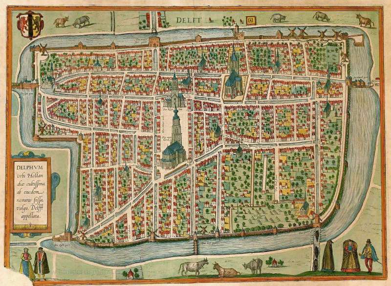
A proof copy of Joan Blaeu's map of Delft (before 1649).
A map of Delft by Joan Blaeu (1649) (fig. 10 & 10a).
Joan Blaeu (1596–1673) was the eldest son of Willem Janszoon Blaeu (1571–1638), and was probably born in Alkmaar in the province of Noord-Holland in the final years of the 16th century. He was brought up in Amsterdam, and studied law at the University of Leiden before going into partnership with his father in the 1630s. He became chief cartographer to the Dutch East India Company from 1638, and from 1651 to 1672 he served on the Amsterdam City Council without a break, holding several public offices, and also invested in Dutch colonial interests in North America.
Blaeu's main work was Theatrum Orbis Terrarum (or Atlas Maior as it had become known). The Atlas had expanded to between 9 and 12 volumes, depending on the language. With over 3,000 text pages and approximately 600 maps, it was the most expensive book money could buy in the later seventeenth century.
In 1649, Blaeu published the Novum ac Magnum Theatrum Urbium (part 1: Belgica Libera ac Foederata, with Dutch cities and part 2: Belgica Regiae, with Flemish cities) with maps of the most important (fortified) cities. His plan to eventually compile the maps of all the cities of the world in a large series of city books did not materialize. That same year, 1649, the Dutch-language edition Toonneel der Steden van de Vereenighde Nederlanden, Met hare Descriptions, and Toonneel der Steden van's Konings Nederlanden, with her Descriptions (two volumes) also appeared.
The six-part Leiden edition of Toonneel des Aerdrycks dates from 1659. In the second edition, due to a large-scale re-conquest of land by the Republic, Blaeu had to transfer several towns to the volume showing towns of the Republic, and as a consequence this volume became larger than the other, thus the composition of the atlas became linked to the struggle for independence of the Republic.
Nothing gives a more beautiful and magnificent picture of the Dutch Golden Age than the more than 200 plans of towns of the Northern and Southern Netherlands in the Toonneel der Steden (Theatre of Towns). From 1649 onwards, one year after the end of the Eighty Years' War, Blaeu presented the Dutch towns, whether they were liberated, or not, in all their pride. Blaeu's town plans are so characteristic and have so often been reproduced that they have become a part of our collective memory.
Although Blaeu used some copperplates of previous publishers, his maps are for the most part made in his own workshop. So most towns were represented on new copperplates, based on the examples sent by city councils. If an up-to-date map was not available, Blaeu asked for a revised version of an older map.
The Blaeu map of Delft accurately follows that of Boxhorn, published in 1632, on page 158 in Theatrum sive Hollandiae Comitatus by Hendrik Hondius in Amsterdam.
Click here to access a high resolution digital image of Blaeu's map.

Published in Amsterdam
Joan Blaeu

Published in Amsterdam
Joan Blaeu
1649
- justification: East-Nord-East above.
- dimensions: 37.5 x 49 cm.
- above center: a cartouche, written in thin letters: "Delf."
- top right: an empty vignette
Blaeu converted Boxhorn's map of Delft into the folio-format. A comparison with the proof copy and the revised map presents the following changes:
- The vignette in the middle was given another inscription.
- The Delft emblem on the top left of the proof copy was moved to the right side. The left-hand one became an emblem of Holland.
- The index of the proof copy, originally intended as a large vignette on the top right, was moved to the below left.
- The Doelenstraat was lengthened, with a new bridge over a new canal (now Raam, north-side from Paardenmarkt).
- A windmill at the corner of two canals (present Achterom and Zuiderstraat), by Boxhorn and in the proof copy (Blaeu) depicted with blades, had become a trunk without blades.
The proefdruk designed after Boxhorn's necessitated a few topographical changes to be published in Joan Blaeu's Stedenatlas.
Information about the map of Delft in the Stedenatlas van de Nederlanden (City Atlas of the Netherlands) by Joan Blaeu (1649):
- dimensions: 37.5 x 49 cm.
- justification: East-North-East above.
- top center: vignette "DELFI BATAVORUM / vernacule / DELFT"
- top left: emblem of Holland.
- top right: emblem of Delft.
- left-hand vignette: index 1–37 in 5 columns (37 streets and monuments named expressly in the map)
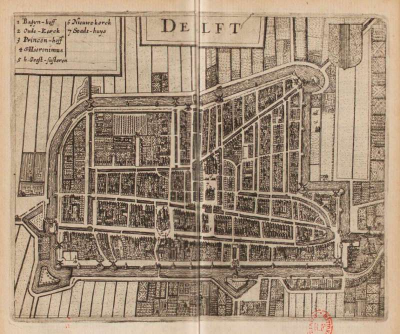
A map of Delft (fig. 11) in Matthäus Merian's Topographia Germaniae Inferioris (1642–c. 1660s).
Topographia Germaniae is a multi-volume series of books created by engraver Matthäus Merian and writer Martin Zeiler (1589–1661) and published in Frankfurt in 38 parts. Engravers Wenceslaus Hollar, Caspar Merian, and Matthäus Merian Jr. also contributed illustrations.
Merian (1593–1650) was a Swiss-born engraver who worked in Frankfurt for most of his career, where he ran a publishing house. He was a member of the patrician Basel Merian family. Merian learned the art of copperplate engraving in Zurich. He next worked and studied in Strasbourg, Nancy, and Paris, before returning to Basel in 1615. The following year he moved to Oppenheim, Germany where he worked for the publisher Johann Theodor de Bry (1561–1623), who was the son of renowned engraver and traveler Theodor de Bry. In 1623, Merian took over the publishing house of his father-in-law after de Bry's death. In 1626 he became a citizen of Frankfurt and could henceforth work as an independent publisher. He spent most of his working life in Frankfurt.

Publisher: Frankfurt am Main; Bey Caspar Merian
Engraved by Matthäus Merian
1642—c. 1660s
A map in the Stedenatlas by Janssonius (1657), by Erven Janssonius van Waesberge (1682)
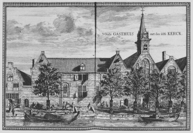
A large scale wall map of Delft, called Kaart Figuratief, published by Dirck Evertsz. van Bleyswijck in 1678 (fig. 12).
The former mayor of Delft, Dirck Evertsz. van Bleyswijck (1639– in Delft –1681), author of the foundational book on Delft, Beschryvinge der Stadt Delft (Description of the City of Delft), was commissioned in 1675 to produce a map of Delft with accompanying images of buildings and cityscapes, which is known as the Kaart Figuratief. When the map was ready in 1678, it consisted of a bird's-eye view, a view of Delft from the west, Delfshaven seen from the Maas, 22 images of buildings, two maps of Overschie and Delfshaven, four family coats of arms of Delft mayors and a short text with a description of the city of Delft. The floor plan with the border prints could be put together into one monumental whole. The map also shows a coat of arms of Delfland and the coats of arms of the 13 main crafts, two coats of arms of Delft, a representation of the College van de Groote Vischerije van Hollant ende Westvrieslant with the coats of arms of Delft, Schiedam, Enkhuizen, Den Briel and Rotterdam.
The Kaart Figuratief, which is now in the collection of the Delft Archives, is considered a pinnacle of Dutch cartography. It shows Delft in a period of great prosperity, when ships from the Delft VOC chamber sailed to the Indies, Anthonie van Leeuwenhoek made his scientific discoveries and Delft Blue was busy conquering the world. The Delft city council was proud of its city, and the map therefore served to promote Delft, far beyond the city limits. The size of a complete Kaart Figuratief measures an impressive 185 x 205 cm. and was printed from four copper plates with the northeast at the top. It was distributed throughout the Netherlands and the world by the city in an effort to promote the city after the infamous Rampjaar (or Year of Disaster). It was often re-published and adapted. Side views were added in the second edition as well as in the expanded version by Boitet in 1729.
This is the most reliable map of Delft before the cadastre, and it can be used today for a walk around Delft's historic center. But the map is more than just a city map, it also shows the buildings and monuments that people were proud of and that still define the face of the city today. The Kaart Figuratief has made a significant contribution to the image of Delft as a "pearl of the Golden Age" and shows the city at its best. Many locations linked to the life and work of Vermeer can be accurately pinpointed. In the case of the Kaart Figuratief, we should remember that it rolled off the presses in 1678, three years after the artist's death. Vermeer's pride in his home town is evident in the famous View of Delft, perhaps the most important townscape in European easel painting.
In 1703 the city map was reprinted, of which the image below is an example. The four copper plates have been adapted on various points for that occasion.

Published in Delft by Dirck Evertsz. van Bleyswijck
1675–1678
81.5 (82.5) x 124.5 (125.5) cm.
Kaart Figuratief (1675–1678) in detail
- dimensions: 81.5 (82.5) x 124.5 (125.5) cm. Printed with four copper plates (the plates are housed in the Stedelijk Museum "Het Prinsenhof." It is still possible to make new prints of the Kaart Figuratief with these plates.)
- justification: East-Nord-East above.
- center top: two emblems of Delft.
- top left-hand: depiction of the "College/VAN DE GROOTE / VISCHERIJE / VAN / HOLLANT/ende/WESTVRIESLANT" with emblems of Delft, Schiedam, Enkhuizen, Brielle, and Rotterdam.
- right-side top: small map of the "HOOGH HEEMRAEDSCHAP VAN DELFLANDT" (Water and Dyke Board) with above the emblem of Delfland and beneath the pictures of the "Huis Honselaersdijk" and Rijswijk stylistic emblems of the "13 HOOFT AMBACHTEN" resp. 13 SLUYSEN VAN DELFLANT" (watergates) surrounding the picture.
- right-side below: "OP D'AFBEELDINGE DER STADT DELFT" / Door bevel van de Hoogh-Achtbare Heeren / Burgemeesteren / der selve uytgegeven" (Picture of the city of Delft / published by the order of the city's honorable Mayors); beneath a poem in 14 lines, signed "CONSTANTER" (= Constantijn Huygens sen.). Beneath: "met Privilegie voor 15 Iaren." Surrounded by depictions of ceramic-making.
- left-side below: 4-part compass-rose, measure: 13 cm. = 50 "Delflandsche ofte/Rynlandsche Roeden" (rod = old square measure)
- bottom: "Amsterdam, by Pieter Smith; left below: 'I. De Ram Fecit."
Click here to download a 16,000 x 12,000 (100 MB) scan of the Kaart Figuratief.

 St Luke guild
 A detail of the figures showing the principal wares of Delft, faience and clothe


Coenraet Decker (1650–1685) won, together with Dirk van Bleiswijk, the right to produce the Beschryvinge der stad Delft. He is said to have been a pupil of Romeyn de Hooghe and married Aechje Jans in 1673 in Sloterdijk at the age of 23.. In the 1670s he worked on the map of Delft and produced a series of separate plates illustrating the town's major buildings.


A map of Delft (fig. 13 & 13a) in Teatro della Guerra by Vincenzo Maria (Padre) Coronelli (1650–1718) 1706.
This plate shows a plan of Delft with a keyed index to the principal buildings. The author of this work, a Franciscan priest (1650–1718), spent most of his life in Venice. He was a noted theologian and was appointed as Father General of his order in 1699. At that time he was already famous as a mathematician, cartographer and globe maker. He was very influential, compiled and engraved over 500 maps. His most well known work is the two-volume Atlante Veneto but is is equally well known for his very large terrestrial and celestial globes. One, fifteen feet in diameter he made for Louis XIV of France.
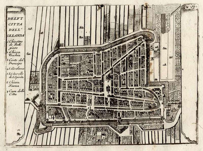
P. Coronelli
Etching/engraving on hand laid (verge) paper, ca. 15.9 x 11.5
1706
A view of Deflt by Vincenzo Maria (Padre) Coronelli 1706.

P. Coronelli
Etching/engraving on hand laid (verge) paper, c. 24 x 7 cm.
1706v
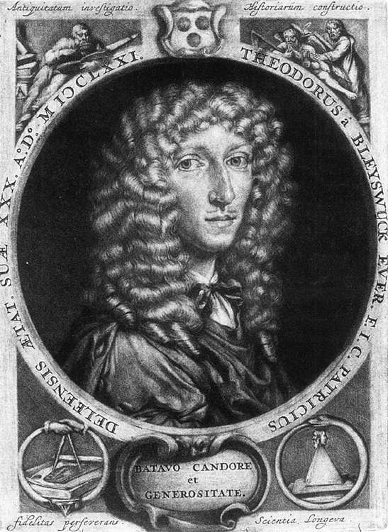
Dirck Van Bleyswyck's Beschryvinge der Stadt Delft and the Kaart Figuratief
One of the great expressions of Delft's civic pride was the publication of Dirck van Bleyswyck's Beschryvinge der Stadt Delft (The Description of Delft), an invaluable 900 page history of the city and one of the most ambitious seventeenth-century projects of its kind. Van Bleyswijck (1639–1681) was born into a prominent family and was sheriff, orphan master, and burgomaster as well. He is known to have traveled extensively throughout the Seventeenth Provinces.
Age of Thirty
Johannes Verkolje
1671
from Beschryvinge der Stadt
Delft, private collection
Van Bleyswijck (fig. 14) must have been an exceptionally resourceful Dutchman, full of love and pride for Delft. At the time the Beschryvinge der Stadt Delft was first published he was only twenty-seven or twenty-eight years old. The idea for the book was born in a peculiar circumstance. Although Van Bleyswijck was forced by an illness to abandon plans for a tour through the Netherlands, France, and Italy, he decided to take advantage of his bed-ridden condition to explore the history of his hometown. The book chronicles the city's history, highlighting the greatest accomplishments of its citizens and describing Delft's important monuments. Van Bleyswijck noted with disappointment that his own generation of Delft citizens was more fascinated by the foreign imports and modes rather than by their own cultural heritage.
Having noted Van Bleyswijck's ingenuity, the town council of Delft commissioned a celebratory map called the Kaart Figuratief and put him in charge of the impressive task. The undertaking was sponsored chiefly by the Delft elite burger class, which dominated all aspects of civic life and was eager to extend its influence and enhance their own prestige.
The Kaart Figuratief, undoubtedly the most important map of Delft, is described as a 'true topographical monument' (B. van 't Hoff)Bert van 't Hoff, Oude plattegronden van de stad Delft (Rotterdam: Den Haag, 1962), 10. . However, it is not a map in the modern sense; rather, it is a hybrid of a map, an aerial photograph, and a theatre stage in which the whole town of Delft is seen from a bird's-eye view with buildings shown in isometric perspective. The drawing's three-dimensional relief offers an unparalleled sensation of a real brick-and-mortar town in miniature, and it is difficult not to be moved by it. Beautiful as the Kaart Figuratief may be, it still has one drawback for the modern historian: it depicts a smaller number of buildings on any given city block than there actually were. Thus, exact measurements and identifications of specific buildings are not always possible. It also does not show the improvised wood structures in which the poor lived in the areas immediately surrounding the walled town.

Map of the river Maas
Jacob Quack
1665
Collectie Gemeentearchief, Rotterdam
The Kaart Figuratief was very likely inspired by a map of the Maas River Delta (fig. 15) published by Jacob Quack in 1665 in Rotterdam. In this map, the port city was prominently displayed, while Delft clearly had a secondary role. The Kaart Figuratief was not made only to decorate Delft public buildings, but was sent to foreign dignitaries and authorities of other Dutch cities.
Apart from the detailed map of Delft, the Kaart Figuratief consists of a large profile of the city, a smaller profile of Delfshaven, 24 small city-views, prints of small maps of the stadsheerlijkheden (a sort of suburb) four emblems of the city's principal burgomasters, and a short description of the city. Its borders were decorated with coats of arms, Cupids, fishes, storks, human figures (such as those of the claymixers, clothe-cutters, both important occupations for Delft's economy) symbolic figures and a 14-line poem by Constantijn Huygens, a sort of complete Renaissance man of the Untied Provinces. By representing Delfshaven (at that time a Delft municipality), Delft cast itself as an important seaport and boasted the headquarters of the Hoogheemraadschap van Delftland, the commission that exercised power over all of the vital waterway system of the region. In the lower corner right of the map male figures lie among a heap of the city's most important products: faience and cloth.
With these separately printed features it was possible to compose a large monumental wall map or to arrange it in three combinations for smaller prints. Detailed instructions for the arrangements ("Onderrechtung" resp. "Advertentie") by Van Bleyswijck were published.
Naturally, the greater part of the Kaart conforms with the older map of Blaeu. But much work had to be done just the same to bring the map up to date. Van Bleyswijck reports that in 1676 the landmeter (surveyor) Jacob Spoors, together with a number of assistants made a detailed surveying of the city and were paid 174 guilders by the magistrate. The most significant novelty in Delft topography was the construction of the Paardenmarkt upon the site of the area demolished by the Delft explosion of the gunpowder-magazine in 1654.
Various historical documents, including bills and receipts from the years 1675 to 1677, are housed in the Delft Municipal Archive. These documents reveal the process of the Kaart's production. The total amount of the costs was 2,666 guilders 15 stuiver. A medium-sized house in those times might cost from 800 to 1,000 guilders.
Van Bleyswijck and Vermeer
While Vermeer died too late to have included Van Bleyswijck's map in his painting, his name was mentioned in the earlier Beschryvinge der Stadt Delft. This work was published in 1667, the very year that Vermeer executed his masterwork The Art of Painting. In this work, Clio holds her trumpet, a symbol of fame, directly beneath a view of the Hof in The Hague, the seat of government. The artist has begun his painting by depicting Clio's laurel wreath, a symbol of honor and glory.
Van Bleyswijck commented that artists bring glory and distinction to their respective cities, a concept that had already been expressed in ancient Greece. Van Bleyswijck lamented that too often fame comes to them only after death. Bound by convention to limit his praise to artists already deceased, Bleyswijck listed Vermeer only as one of the artists active in Delft; he did not include one word about Vermeer's work. To the reader of this history of Delft, Vermeer remains as indistinguishable from his contemporaries as the artist in this painting. Indeed, while Vermeer probably depicted his artist from the rear to assert the universality of his allegory, he may also have done so to emphasize the anonymity experienced by the artist during his lifetime even as he brings fame and glory to his homeland.
:
Johannes Vermeer and the Art of Painting: Art and History
Johannes de Ram engraved the plan of Delft while Decker was responsible for engraving all the pictorial elements which included many propagandistic embellishments. A number of craftsmen and draughtsmen were employed. Payments were made to the accomplished painter Johann Verkolje (1650–1693) for the drawings of Delfshaven in profile, the large, panoramic profile of Delft, and the two churches with their towers. Pieter van Asch (an excellent still life painter) made two drawings of the Overschie and Voorburg. Andries Hoogeboom was the typesetter, Andries Smith the printer and Jacobus Robijn hand-colored the maps. Moreover, the original maps were adorned with elaborate gilt frames. Steven Swart, a woodcarver, and Joris Arentsz, a painter and gilder, made eleven elaborate frames with carefully orchestrated symbolic images all determined by the erudite Van Bleyswijck. For example, the sun that dominates the top of the frame, now gracing one of the frames in the Delft Prinsenhof, is explained in Latin: Sol iusteae illustra nos (The sun of justice shines on us)
Van Bleyswijck published in the Beyvoegselen (attachments) to the second volume of his Beschryvinge a "Sleutel ofte uytlegginge van de Sinne-beelden..." (key for the interpretation of the allegories). This led to the assumption that the second volume of Beschryvinge van Delft was published soon after 1677. For the new volume Van Bleyswijck made use of a number of plates intended for the Kaart Figuratief (mainly the city views), to save money for the production of new plates. Later, in 1729, the Delft citizen Reinier Boitet (1691–1758)Kees Kaldenbach, "Reinier Boitet (1691–1758)," in A multimedia encyclopedic web site on Johannes Vermeer & life in Delft, accessed November 19, 2023. used many of the plates from the Kaart Figuratieffor his own Beschryving der stad Delft (which was little more than Van Bleyswijck's work with some corrections and attachments).